
The War
The War
England and France had been enemies for centuries before either claimed parts of the New World. In North America, the conflict involved settlers, soldiers and native peoples. The climax was the French and Indian War.
As a result of France's growing attempt in early 1754 to connect her extensive dominions in North America by uniting Canada with Louisiana, she took possession claimed by England to be within the Province of Virginia and began a line of military posts from the Great Lakes to the Ohio Valley. North Carolina was the first colony to respond to Virginia Governor Dinwiddie's call for military assistance; voting to support troops outside of its own borders in behalf of a common cause and defense.
North Carolina's Colonel James Innes (1700-1759) was commissioned commanding officer of all provincial forces in the first Ohio expedition by Governor Dinwiddie in 1754. Under Innes, the North Carolina Provincial Regiment consisted of approximately 450 men, including Lieutenant Hugh Waddell.
Disbanded in the fall of 1754, North Carolina Provincials returned to service under Major Edward Brice Dobbs in Braddock’s 1755 campaign, and during a New York Expedition in 1756. North Carolina continued to send troops throughout the war to the aid of the other colonies and participated in the 1758 Forbes Campaign. In 1759, war broke out between the English and their Cherokee allies following the murders of as many as 40 Cherokee warriors by Virginians. Under the command of now-Colonel Hugh Waddell, North Carolina Provincials were tasked with defending their own frontier and aided Virginia in 1761, when the Cherokees were finally defeated.


Fort Dobbs
Fort Dobbs

"A good and Substantial Building of the Dimentions following (that is to say) The Oblong Square fifty three feet by forty, the opposite Angles Twenty four feet and Twenty-two, In height Twenty four and a half feet as by the Plan annexed Appears, The Thickness of the Walls which are made of Oak Logs regularly Diminished from sixteen Inches to Six, it contains three floors and there may be discharged from each floor at one and the same time about one hundred Muskets the same is beautifully scituated in the fork of Fourth Creek a Branch of the Yadkin River."
Fort Dobbs was the only permanent frontier provincial fort in the colony of North Carolina. Construction began in late 1755 and was completed by October, 1756. It served as the military headquarters for the Frontier Company (approximately fifty men) as well as a safe-haven for settlers.
The fort was attacked on the night of February 27, 1760 when more than sixty Cherokees were repelled. The garrison suffered two men wounded, one of whom later died, as well as having one colonial boy killed. The Cherokee were reported to have lost 10-12 men killed and wounded. Waddell described the encounter in a dispatch to Governor Dobbs:

"We had not marched 300 yds from the fort when we were attacked by at least 60 or 70 Indians ... We recd the Indian's fire: When I perceived they had almost all fired, I ordered my party to fire which We did not further than 12 Steps each loaded with a Bullet and 7 Buck shot, they had nothing to cover them as they were advancing either to tomahawk or make us prisoners ... the Indians were soon repulsed with I am sure a considerable Loss, from what I myself saw as well as those I can confide in they cou'd not have less that 10 or 12 killed and wounded ... On my sided I had 2 Men wounded one of whom I am afraid will die as he is scalped, the other is in a way of Recovery, and one boy killed near the fort."
By the end of 1761, the British had essentially won the war. No soldiers garrisoned the fort, but a caretaker watched over it. In March, 1764, colonial leaders removed all the supplies from Fort Dobbs and ordered it abandoned. The neglected fort was in ruins by 1766. By 1800 it was a farm field.
Archaeology
Archaeology

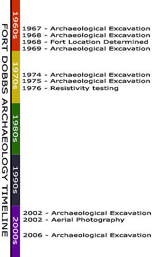
Archaeology has been used to resolve three key issues about Fort Dobbs:
Determine the location of the fort
Define the character of the fort
Document through artifacts the nature of life at the fort
Official archaeological excavations begun in 1967, led Dr. Stanley South to confirm the exact location of the fort by 1968.
During 2005 and 2006, Dr. Lawrence Babits of East Carolina University, a scholar trained in archaeology, military architecture and history, reevaluated the results of all previous archeological work and performed additional archaeology to clarify certain issues. Babits' study revealed that sufficient evidence exists to recreate the fort in a historically accurate manner. Babits unveiled his extensive archeological research report to the public during a press conference held at the Statesville Civic Center. The event was attended by dignitaries from around the state.
According to written documents and the results of archaeological excavations, the original fort
was a modified wooden blockhouse-type structure.
measured 53'x 40'.
had 24'x22' flanker extensions at two of its four corners.
boasted a fireplace, an extended cellar and an interior well.
could accommodate 100 soldiers firing muskets on each of its three floors.
was surrounded by a ditch.
had a door protected by a palisade wall.
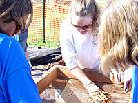
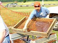
Today, recovered artifacts continue to undergo preservation, conservation and cataloging at the Office of State Archives Research Center in Raleigh.
Click the aerial image below to view enlargement of the 2002 excavation. Other photos were taken during the 2006 excavation.


Settlement
Settlement

The settlers who established themselves on the western edge of North Carolina almost all originated in Pennsylvania. Many began moving south in the mid-1730’s, some settling in western Maryland and Virginia’s Shenandoah Valley for several years before following the Great Wagon Road to western NC as early as 1749. The settlers were drawn by inexpensive, fertile land. North Carolina was also far removed from the threat of French-allied Native American attacks until the start of the French and Indian War in 1754.
By 1755, 35 families had established themselves in what was called the Fourth Creek Settlement. These families lived along Third, Fourth, and Fifth Creeks. The descendants of many of these early settlers are still in the area today.
Settlers continued to trickle in during the French and Indian War and Anglo-Cherokee War. After the Anglo-Cherokee War was concluded in 1761, settlers began to find their way to the Fourth Creek Settlement in large numbers. By 1765, the Fourth Creek Settlement had 119 landholders living within approximately ten miles of the Fourth Creek Meeting House (established in 1756). In addition to the white settlers, there were at least eleven enslaved people of African descent in the Fourth Creek Settlement by 1765.
While most of the settlers were farmers, some skilled tradesmen can be documented. By 1765, there were three blacksmiths, a bricklayer, two carpenters, a clothier, a cooper, two cordwainers, four millers, nine planters, a reverend, a schoolmaster, a shoemaker, a silversmith, two surveyors, four tailors, and five weavers.
The following link is to a Google Map of the settlement of western North Carolina: This Map and the following information are based on land patents which can be found in the North Carolina Land Grant Image and Data website.
Fourth Creek Settlement Property Owners 1749-1765 by Date of Land Grant
1749
James MacIlwaine - Surveyor
William Morrison – Miller and Planter
1750
James Hannah
Henry Hendry - Schoolmaster
Henry Huey - Weaver
William Watt - Clothier
1751
Joseph Davidson – Daughter Rachel was born at Ft Dobbs on March 23, 1756.
1752
Andrew Allison - Tailor
Robert Allison
Thomas Allison Sr. - Planter
James Hall Sr
James Hemphill - Planter
Richard Lewis
James Miller - Tailor
Andrew Morrison
James Morrison - Tailor
John Oliphant - Miller
Moses Potts
Alexander Reid
Samuel Reid – Cordwainer.
Richard Robinson
Fergus Sloan
James Stewart - Weaver
1753
George Davidson
John McElwrath - Planter
Robert Simonton
1754
Henry Chambers
John McKee
Thomas Porter – Cooper
1755
William Archibald Sr.
William Eslavin – Weaver
John Dobbins - Blacksmith
Henry Potts – Planter
Michael Robinson
1756
William Grant
Patrick Campbell
1757
Mary Armstrong
Patrick Duffey
Thomas Hall - Weaver
William Simonton - Planter
Samuel Thornton
John Wilson
James Woods
Robert Woods – Carpenter
1758
James King
John Knox - Blacksmith
William Ireland – Cordwainer
Samuel Snoddy
1760
Allen Alexander
James Brandon – Miller
George Elliot - Blacksmith
Christopher Erwin
Thomas Gillespie
George Hall
Walter Lindsay
James Potts
William White
1761
John Archibald
Thomas Archibald
William Archibald Jr
David Black
Hugh Bowman
William Carson
Robert Cavin
Samuel Cavin
Peter Flemming
James Hall Jr – Reverend
Hugh Hall
James Mordoch
John Potts
Andrew Reid - Silversmith
Edward Roberts
William Stevenson – Tailor and Planter
Jacob Thomas - Surveyor
James Watt
Francis Wilson
1762
David Andrew
William Bowman
Jacob Crawford
George Erwin
Samuel Harris
John Leech
John Ireland
James McCullough - Bricklayer
George McDonald
James McKnight
William McKnight
Jacob Nichols
Robert Steele
James Stewart
1763
John Bickerstaff – Weaver
John Jacks – Planter
James Rosenborough
1764
William Bailey
Christopher Houston – Miller
Samuel Houston
Andrew Ferguson – Carpenter
John Nisbet II
1765
Gabriel Alexander
Adam Allison
William Beard
John Bone Sr.
William Bone
David Caldwell
Daniel Boyd
Robert Boyd
Robert Hill
James Houston
William McClelland – Planter
James Milligan – Planter
Patrick Morrison
James Purviance
Hugh Reed
John Rosenborough
Samuel Rosenborough
Adam Simonton
Ninian Steele
Joseph Wasson – Shoemaker